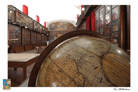
The IGMI Library
The History
In 1865, Florence became the temporary capital of Italy. Many offices and services of the Reign of Italy, such as the “Technical Office” of the Italian Army General Staff, were transferred from Turin, the first capital, to Florence.
The IGMI Library has always been located in the big Hall of the Santissima Annunziata Monastery. The Hall, dating back to 1694, is decorated with two frescoes representing important events occurred to the members of the Servite Order.
The first documents hosted in the Library were collected from the dissolved “Ufficio Topografico Toscano” and other services of the pre-existing Italian States. Some of the most significant documents are the “Carta topografica e geometrica della Toscana”, drawn in 1830 by Giovanni Inghirami and other works by famous geographers, such as Tommaso Borgonio – who worked during the XVII century in Piedmont - and Giovanni Rizzi-Zannoni, who made the first geodetic map of the Kingdom of the two Sicilies.
At the end of the XIX century, a great amount of documents needed to be catalogued and in 1908 the inventory was completed. In 1928, the Library became the Military Library of Florence and in 1938 it was opened for public consultation.
From 1944 until the end of WW II, the IGMI as well as the Library were transferred to Dobbiaco – Toblach (Bolzano).
In 2002, the Library was entitled to Attilio Mori (1865-1937), topographer at the IGMI, Director of the Library and Professor Emeritus at the University of Florence.
The Collections
In the Library are currently hosted:
- About 120 000 books covering the geographic field and its relevant disciplines such as : Geography, Geodesy, Cartography, Topography, Astronomy, the History of Cartography, Explorations and Discoveries, Anthropology, Ethnography, City Planning, Regional Planning, Remote Sensing, Information Technology, GIS – Geographic Information System, etc... and publications of general interest and related to the military field (history, politics, economics, etc...);
- A collection of nearly 700 geographic Atlas, the oldest dating back to 1570;
- A map collection of ancient and modern maps, the majority of the latter have been acquired through exchanges with other Cartographic societies around the world;
- A magazine section collecting 750 national and international magazines acquired by the Institute through an exchange partnership with other Institutes and organisations: “L’Universo” and the “Bollettino di geodesia e scienza affini”.
- The “Bollettino di geodesia e scienza affini” is no longer issued but features in the Universo magazine.
- A collection of photographs, the oldest dating back to 1865.
Ancient works
The following ancient books can be found in the Library:
- N° 2 Incunables
- N° 22 books of the XVI century
- N° 19 books of the XVII century
- N° 128 books of the XVIII century
Main works collected in the Library
- The “Golden Legend” by Jacopo da Varagine, published in 1478 by Johannes Zainer;
- A Venetian edition of the “Rime e Trionfi” by Petrarca and published in 1488;
- Two editions of the “Theatrum Orbis Terrarum” (the “Theatre of the World”) by Abraham Ortelius; the first one of 1570 and the fifth one of 1595;
- “La Difesa et offesa delle piazze”, a handbook about fortifications and the art of war, by Pietro Paolo Floriani from Macerata, published in 1654;
- “Isolario” by Benedetto Bordone, an atlas displaying all the most famous islands of the world known in 1547;
- "Theatro delle città d'Italia” by Bertelli, printed in 1629;
- The only sample of the “Carta d’Italia” by Giovanni Antonio Magini, engraved by Wright and published in 1608;
- An autograph manuscript belonging to Giovanni Antonio Rizzi Zannoni, where he wrote his astronomy and trigonometric annotations during the realization of the map of the Kingdom of the two Sicilies.
Atlas
There is a valuable collection of ancient and modern geographic atlas from all over the world. One of the most noteworthy is the “Atlante geografico d'Italia” (The Geographic Atlas of Italy), by Magini, printed posthumously in 1620.


